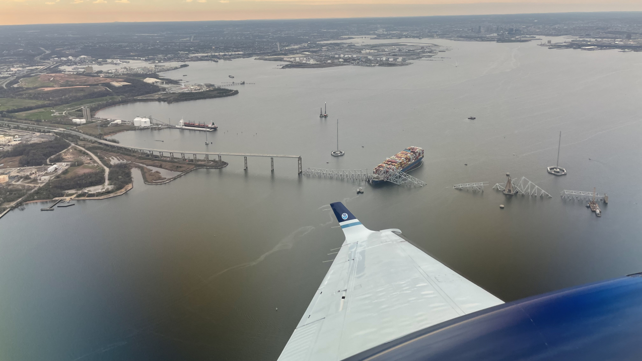
March 28, 2024: View from NOAA King Air N68RF aircraft during a navigation survey following the collapse of the Francis Scott Key Bridge in Baltimore. The bridge and the MV Dali, the container ship which collided into it, are visible. (Image credit: Lt. Eric Fritzsche/NOAA Corps )
In the aftermath of the collapse of the Francis Scott Key Bridge on the Patapsco River, NOAA, alongside local, state and federal agencies, have been working around-the-clock to come to Baltimore’s aid. The tragedy resulted in the loss of six lives and the immediate closure of the shipping channel leading into and out of the Port of Baltimore. Reopening the Patapsco River channel is critical to the U.S. economy, with the closure having lasting impacts on U.S. trade routes.
Immediately following the collapse of the bridge, NOAA’s Office of Response and Restoration’s Disaster Preparedness Program activated the National Ocean Service’s Incident Management Team to collect information and enhance coordination and response efforts, directly supporting the federal response. Additionally, the regional NOAA Scientific Support Coordinator was notified and responded on-scene in support of the U.S. Coast Guard and is present in command supporting ongoing operations. NOAA is now knee-deep into the disaster response and recovery phase.
Here are 5 areas of actions that NOAA took or is taking to support Baltimore’s salvage efforts:
NOAA helped establish auxiliary navigation channels
On April 21, NOAA's Office of Coast Survey again deployed its Navigation Response Team to survey a portion of the Patapsco River so that a fourth temporary channel could be opened, helping to clear a limited access deep draft channel to 35 feet, the greatest depth to date since the Francis Scott Key Bridge collapsed. Additional obstructions were identified during that process and salvage teams removed the debris found during the survey. This deeper channel was opened on April 23 to allow vessels of a greater draft to pass through a portion of the river.
On April 17, the U.S. Coast Guard requested NOAA’s expertise to execute hydrographic survey work needed to open a third temporary channel to allow essential commercial traffic access to the Port of Baltimore. NOAA's Office of Coast Survey worked alongside the Port of Baltimore, the U.S. Coast Guard, the U.S. Army Corps of Engineers, Baltimore District and other partners to establish the 20-foot Fort Carroll Temporary Alternate Channel. These efforts also allowed the placement of new temporary channel buoys, marking the channel's path. Earlier channels opened April 1 and 2, respectively, and are serving as alternate routes for shallow-draft ships to pass around the wreckage of the Francis Scott Key Bridge via the undamaged bridge spans on the north and south sides of the main shipping channel.
NOAA aircraft captured high-definition aerial imagery to update NOAA navigational charts
NOAA’s National Geodetic Survey collected emergency response imagery while aboard one of NOAA’s King Air aircraft to support updating the shoreline features of impacted NOAA nautical charts. The enhanced nautical charts helped aid responding local, state and federal agencies in their missions through improved situational awareness.
NOAA meteorologists provided forecast support to emergency managers
On the same day of the incident, NOAA’s National Weather Service deployed meteorologists from the Baltimore/Washington Weather Forecast Office to the Maryland Emergency Operations Center to provide onsite forecast support. Continuing to support operations and salvage, NOAA forecasters now provide regular, remote briefings. To help with recovery and salvage efforts, NOAA created a webpage for access to hour-by-hour weather forecasts for the Francis Scott Key Bridge.
Real-time current and meteorological measurements being gathered, shared
NOAA’s Center for Operational Oceanographic Products and Services deployed a quick response buoy (CURBY) that provides real-time currents and meteorological measurements in the vicinity of salvage operations.
Additional NOAA support happening behind the scenes
Off the water, NOAA’s Office of Coast Survey and the Center for Operational Oceanographic Products and Services are providing a range of decision support products to the maritime community and agencies involved in the response.
> For media inquiries, please contact Scott Smullen at scott.smullen@noaa.gov or (202) 494-6515.


